jueves, 14 de abril de 2011

description of photographs

dog chow chow


Due to his teddy bear appearance, this breed of great beauty has gained manyadherents in recent years. Originally from Asia especially China where it is prized forits tasty meat. The Chow Chow is a breed of unique features square, as broad, flathead, wide muzzle and deep blue-black tongue, frowning and walking typical ChowChow. There are two variants, the long hair and short hair. The long hair you haveabundant, straight, coarse, short hair is harder and thicker. Stresses his head on the body, its ears are small, triangular, round and straight edge, big black nose and blue-black tongue. The color of your hair can be anything from gold to dark mahogany,black, blue, tan, white and cream.

mazda 3
se ofrece con carrocerías hatchback de cinco puertas y sedán de cuatro puertas. Ambas versiones del Mazda 3 ofrecen un espíritu deportivo que ha tenido gran aceptación entre los jóvenes. Los detalles deportivos que lo caracterizan son las puertas de acceso a las plazas traseras relativamente cortas, en comparación con los vehículos similares o competidores; la suspensión relativamente rígida y multibrazo en el eje trasero

macdonals
The business began in 1940, with a restaurant opened by brothers Richard and Maurice McDonaldin San Bernardino, California. Their introduction of the "Speedee Service System" in 1948 established the principles of the modern fast-food restaurant. The original mascot of McDonald's was a man with a chef's hat on top of a hamburger shaped head whose name was "Speedee." 
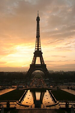
descipcion de la torre eiffel


Torre Eiffel
Tour eiffel at sunrise from the trocadero.jpg
Located in the Champ de Mars at the river Seine, this Parisian monument, symbol ofFrance and its capital, was the ninth most visited country in 2006 and the most visited monument in the world with 6,893,000 visitors in 2007.2 With a height of 300 feet, laterextended to an antenna at 325 meters, the Eiffel Tower was the highest structure in theworld for over 40 years, until surpassed the Chrysler Building, New York, in 1930.
It was built in two years, two months and five days in controversy with the artists of the time, who saw her as a monster of hierro.3 Initially used for military testing withcommunication antennas, 4 today serves as well as tourist attraction as a broadcasterof radio and television.

mi mascota se ha extraviado


good afternoon with this poster I would let you know that my pet chow chow breed islost the day yesterday the last time he was seen was in a park.
is white is 7 months old
provides a good reward to anyone who has information about it, contact the following number 3118495805-6742036
or get closer to the street number 187 57-84

geografia de colombia


La República de Colombia se encuentra al extremo norte de Suramérica, ubicada entre la gran selva amazónica, el istmo de Panamá y los océanos Pacífico y Atlántico (de los cuales recibe fuertes influencias climáticas), siendo además cruzada por la gran cordillera andina, lo que origina una gran variedad de climas y ecosistemas, muchos de ellos propios del país. Su posición privilegiada no solamente proviene por ser el único país de América del Sur que posee dos costas: en el mar Caribe y en el océano Pacífico ( y por tanto una extensa plataforma continental), si no además que se encuentra en la parte media del continente americano, lo que facilita su comunicación con todos los continentes.

Su territorio es cruzado por la línea ecuatorial, dividiendo de éste modo el territorio en los hemisferios norte y sur. Debido a éstas condiciones Colombia no sufre de estaciones, por lo cual no tiene que soportar temperaturas extremas ni a los estragos sufridos por éstas. Además la cercanía al ecuador le garantiza un segmento importante de la órbita geoestacionaria, del espacio aéreo y del espacio electromagnético.2
Los puntos extremos del territorio continental colombiano están al norte en Punta Gallinas, en lapenínsula de la Guajiralatitud 12° 30’ 46” Norte. Por el sur en la Boca de la quebrada San Antonio, en inmediaciones del Trapecio amazónico y localizado en latitud 4° 13’ 30” Sur. Hacia el este tiene como punto de referencia la Isla de San José en el río Negro, frente a la Piedra del Cocuy, localizada en longitud 66° 50’ 54” Oeste. Por el oeste, el Cabo Manglares, en el departamento de Nariño localizado en longitud 79° 01’ 23” Oeste.